New technologies and updates in interpreted products have improved the quality of mapping. To date three mapping editions have been produced.
First edition mapping undertaken between 1973 and 1980 at a scale of 1:63,360, using first edition classifications with national coverage.
The NZLRI database was digitised, between 1977 and 1980, from the NZLRI maps (NWASCO 1975-79). The database consists of a total of about 85,000 map units (with a median size over New Zealand of 153 ha) and their physical resource descriptions. The data were collected between 1973 and 1979 from detailed aerial photo interpretation, large scale resource maps and extensive field work (Newsome 1992).
Although data were stored in a Geographic Information System the main method of spreading the information was via paper maps (NZLRI worksheets) and extended legends.
Edition 2 remapped areas that were amongst the earliest Edition 1 regions mapped (South Auckland, Northland, Wairau/Awatere, and Wellington).
Mapping was undertaken between 1980 and 1984. South Auckland region was remapped at 1:63,360 scale on NZMS 1 sheets, while the remainder were compiled on 1:50,000 scale NZMS 260 (metric) topographic sheets (Newsome 1992).
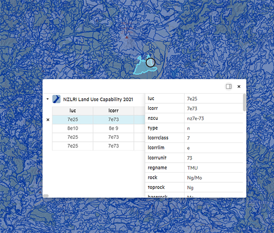
The third edition accessed via the LRIS Portal contains a restructured polygon attribute table to allow the core NZLRIS to complement the newly created fundamental soil layers with minimal duplication.
The NZLRIS layer contains the same information as the NZLRI worksheets. There are about 100 000 polygons (map units) within the NZLRIS, each of which describes a parcel of land in terms of five characteristics or attributes.
Learn More