LUC at local scale
Using Land Resource Inventory and Land Use Capability surveys at local level to achieve sustainable land development and management on farms.
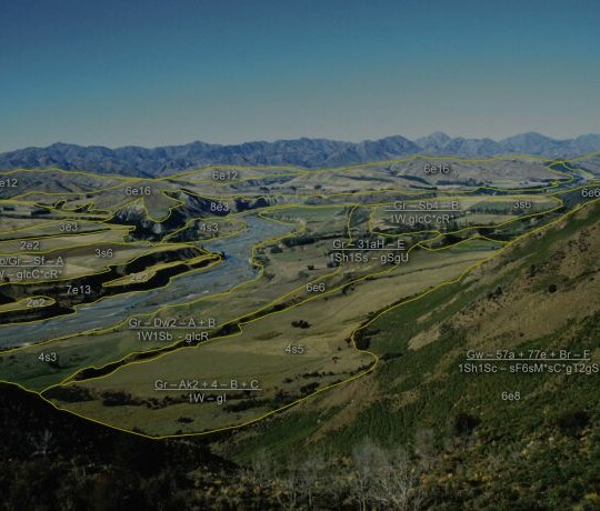
Land Resource Inventory (LRI) and Land Use Capability (LUC) surveys at local level are undertaken predominantly for ‘farm planning’, where LRI and LUC form the basis of developing a programme for improved resource use and management.
Other increasingly common applications include nutrient budgeting and farm development projects.
Five steps are recommended for a farm-level survey:
Project scope
- Preparation
- Project planning
- Survey kit
- Mapping materials background investigation (draft land units)
Field Survey
- Farmers knowledge
- Land Resource Inventory (LRI) mapping:
- Rock type
- Soil
- Slope angle
- Erosion type and severity
- Vegetation cover
Office Work
- Map draughting / digitising
- Land Use Capability (LUC) Classification
- Using LRI factors, together with an understanding of the climate and the experience gained from past land use, the capability of the land for permanent and sustained production can be assessed.
- There are other additional factors when mapping at farm scale that may be relevant including aspect, elevation, and distance to watercourses.
- Extended legend (summarises inventory descriptions by each LUC unit, and typically provides supplementary information regarding land qualities and management considerations)
Applications
- Farm planning
- Nutrient management
- Nitrogen leaching
Adhering to standards, criteria and methodology outlined in the handbook will help ensure a robust survey and LUC classification.
Highly versatile soils have a variety of high producing uses, such as vegetable production in Pukekohe, dairy in Taranaki and Waikato, citrus in Gisborne, or seed production in Canterbury.
Recognising the vital role these soils provide for our export economy, as well as domestic food supply and employment, the New Zealand Government has released a significant policy to protect the most versatile soils from ongoing urban sprawl and rural residential developments.
The National Policy Statement for Highly Productive Land (NPS-HPL) came into effect on the 17 October 2022.
Local Councils have a three-year transition phase to fully identify, map, and manage highly productive land.
The NPS-HPL will enhance protection for HPL from inappropriate subdivision, use, and development.
The NPS-HPL recognises HPL as belonging to Land Use Capacity (LUC) classes 1 to 3, which in its original state comprised around 14% of New Zealand.
However, the Our Land 2021 national state of the environment report highlighted that cumulatively, large areas of HPL have already been lost to urban sprawl and rural residential developments.
To monitor the effects of land fragmentation on HPL availability, a new environmental indicator for HPL was developed. A full description of the land fragmentation indicator is available from Stats NZ.
Actions to improve the identification and stewardship of New Zealand’s highly productive land through the NPS-HPL and the land fragmentation indicator require national coverage of geospatial datasets such as the LUC, S-map, the Land Cover Database, and Protected Natural Areas.
LUC can be used for farm mapping
Beef + Lamb NZ have a guidance which explains that they use the LUC maps “to assess the physical characteristics of the land to aid management of a variety of land management issues”. This guidance also sets out how to develop a Land Resource Inventory and LUC map which they state, “requires a degree of self-calibration”.
Aid farmers in land management
Knowledge Auckland has produced the ‘Farm-scale land use capability classification for Auckland’ Report in 2017. This farm land use capability (FARM LUC) “is to provide a map format which landowners find easier to understand, and more information as an aid for land management, than the existing NZLRI LUC sub-classes and units. It retains existing LUC classes 1 to 8, replaces four sub-classes (indicating general limitations to land use) with 20 specific sub-classes, and replaces unit numbers (denoting different kinds of land but three inconsistent number sets) with a single set of character suffixes.”
Erosion Control
The Ministry for Primary Industries (MPI) have a guidance to identify the land most in need of erosion control treatment by using LUC to classify the land.


