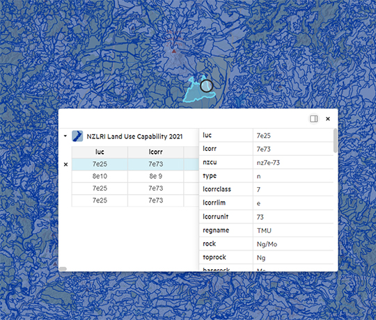
Land Resource Information System (LRIS)

What is the LRIS Portal?

The LRIS Portal is an online geospatial data repository that holds over 200 different land resource data layers for Aotearoa – New Zealand and beyond.

New Zealand Land Resource Inventory (NZLRI) layers

NZLRI is a national spatial database of physical land resource information. It comprises an inventory of five physical factors (rock type, soil, slope, present type and severity of erosion, and vegetation)

Land Use Capability 2021 layer

The Land Use Capability 2021 layer comprises two sets of data compiled using stereo aerial photography, published and unpublished reference material, and extensive field work.

The latest update (Edition 3) includes a new National Land Use Capability legend correlated for all regions across New Zealand. Attributes include original LUC units codes and unit descriptions so that users more familiar with original regional codes and North Island correlations can track the pedigree of units from old to new codes and descriptions.

LRIS Land Use Capability 2021

31 January 2023

A national database of physical land resource information.

The latest update (Edition 3) includes a new National Land Use Capability legend correlated for all regions across New Zealand.
Explore the LRIS Land Use Capability layer

Key features

  • Search for a dataset using a keyword, name of the dataset or click on the map.
  • Download download GIS data as Shapefile (SHP), FGDB, DWG, MapInfo, CSV, Google Earth (KML). More advanced users can use the APIs (Application Programme Interfaces) to stream data directly into desktop applications such as GIS tools and web applications.
  • Metadata and supporting documentation is also available and can be downloaded to support use of the data.
  • You can choose to crop by various geographical extents, such as Territorial and Local Authorities, or Regional Councils.
  • Free — data are provided free of charge under simple licensing arrangements

Meeting the need for a system to promote sustainable land management

Development of the Land Use Capability layer

The first edition NZLRI provides national coverage from mapping between 1973 and 1979 at a scale of 1:63,360. A limited revision regional upgrade of the north Waikato area was completed at a scale of 1:63,360 in 1983. Second edition NZLRI regional upgrades at a scale of 1:50,000 have been completed for Northland, Wellington, Marlborough and Gisborne-East Cape. Third edition NZLRI layers contained a restructured polygon attribute table to allow the core NZLRI to complement the newly created fundamental soil layers with minimal duplication.

Our latest news